VK3ARR's SOTA Blog

Ego loqui ad viros super montes

Month: December, 2015

VK3/VW-007 – Near Boroka Lookout

By the time we’d finished with Mt William and made our way over to Boroka Lookout (about an hour from Mt William), the rain had set in. We sat for a bit in the car eating lunch hoping for a clearing, and as soon as the weather seemed to settle, we jumped out and grabbed the gear.

Boroka Lookout summit is behind the car park, with a large rock pile. We did a bit of bush bashing to get to a spot well within the activation zone. We had taken the vertical instead of the dipole, and set it up quickly. We found a shelter under an overhanging rock, and tried to tune up on 40m, but couldn’t.

We then tried on 20m after shortening the counterpoise to discover the ATU had a loose connection (it’s been through several baggage handling jurisdictions), and with some Macguyver work got it to tune up on 20m. We compensated for poor efficiency with more power, and worked a number of stations to qualify the summit for us both – I worked 5 on 20m, and Leighton worked 4.

Me in front of the shack, after we'd packed up.

Me in front of the shack, after we’d packed up.

It was cosy, even if the shelter was illusory

It was cosy, even if the shelter was illusory

Warren ZL2AJ was on ZL1/BP-237, but we were unable to hear him, nor he us. This was a pity, as it would have been nice to work Warren outside of email. There will be other activations, of course.

After pulling the pin as the rain picked up, we headed down to the Lookout proper, which had stunning views, albeit not quite what we’d anticipated. All up, two summits, 10 points in total, and Leighton introduced to SOTA. Expect to see him out and about a bit in VK2 on the rare occasions he has free time!

Simply stunning.  And the view is pretty good too.

Simply stunning. And the view is pretty good too.

Leighton admires the view

Leighton admires the view

Boroka Lookout, straight down

Boroka Lookout, straight down

VK3/VS-001 – Mt William

On my last trip to Sydney, I had caught up with my old friend Leighton, who first showed me the pleasures of amateur radio when he had his Novice Limited call back in High School. Leighton now works up in Sydney, but maintains a callsign of VK2LI. Plans were hatched that when he came back to Geelong for Christmas, I’d show him the delights of SOTA.

Having then tried to find a decent day that worked for us all, we settled on Sunday the 20th of December, as it was hoped a cool change would bring relief from the 40+ degrees celsius we’d had for the previous two or three days. Saturday had yielded a 45 degree stinker at Geelong, but we held firm. The forecast was for showers to come through about 2pm at Stawell/Halls Gap, so the Grampians looked like a good option. Mt William and Boroka Lookout were chosen. I also eyed off Mt Warrenheip on the way back, if we’d taken the loop option back via Ballarat, for an easy 4 points to take me to 150 points.

The latter wasn’t an option in the end: 45 degree days mean high winds and the inevitable bushfires, and one hit near Scotsburn, Clarendon and Elaine, closing the Midland Highway. This prevented access to Mt Warrenheip, but of more concern to me was seeing how close the fire was burning to Allen VK3HRA’s place. Luckily everything was fine for Allen.

The road closure meant we had to travel to the Grampians via Bannockburn, Skipton and Dunkeld, but the difference in time is minimal, and we reached the Mt William Carpark close to UTC rollover. The sign at the bottom said “Strenuous Walking Required”, which seemed ominous. It was still warm at Mt William at this point, and the wind was very strong.

One of my great fears when walking with others is being the slowest, least fit person in the group. Leighton has a history of bushwalking long distances, so I was prepared to be the weakest link, but a comfortable life in New South Wales has turned him soft, and thankfully he was huffing and puffing more than I was. To be fair, strenuous walking was definitely required. I was pretty stuffed by the time we reached the top too!

It took us about 30 minutes to walk to the top and we set up just after rollover, on air about quarter past. I put up a spot, and we called CQ for a while. We were using the linked dipole, and the FT-857. I had the dial on 5 watts nominal, so under battery it’s about 3-4 watts out. The breeze was blowing, and we weren’t sure if the dipole would hold at the top of the squid pole, but thankfully it did!

The dipole flapping in the breeze

The dipole flapping in the breeze. Wind speed indicated by coax distance from squid pole.

The summit view

The summit view

20151220_122140

Conditions were pretty good, and the summit was qualified in about 10 minutes. Leighton’s dad, Ian, VK3LIJ is also an amateur, and he called in for his first SOTA points too, before we worked Leighton’s son as well during the exchange. Apologies to the waiting chasers as we had a long QSO with Ian, but it’s important to bring more into the SOTA fold!

I handed the microphone over to Leighton after working my 4 to qualify, and we basically swapped the microphone between each other as needed. I worked 9 stations on 40m, and 2 on 20m. Leighton worked a similar amount, including one person who was determined to tell us we were not supposed to be in a National Park on a day of a Total Fire Ban.

To be clear, access to NPs is restricted on Code Red and Extreme fire danger days, while it was a Severe fire rating day in the Grampians. Days of Total Fire Ban are usually declared on days of Severe or above. We had specifically checked access requirements beforehand, given what had gone down at Scotsburn overnight.

Leighton managed the conversation extremely well, simply asking for a signal report in reply.

Leighton works the pile up

Leighton works the pile up

I work the pile up.  Leighton captured my best side here - I may be vain and narcissistic, but I'm vain and narcissistic with a great butt

I work the pile up. Leighton captured my best side here – I may be vain and narcissistic, but I’m vain and narcissistic with a great butt

Spectacular views

Spectacular views

As we hit midday, we decided to pack up and head back down, with a few drops of rain coming our way as we headed down the summit, and on the drive over to our next summit near Boroka Lookout.

ZL1/AK-016 Rangitoto

With a few hours before my flight, I took advantage of the gap to get out and activate Rangitoto Island (ZL1/AK-016).  This island is about 30 minutes offshore of Auckland, and, being a recently erupted volcano, qualifies for VOTA.  Joining me was one of colleagues in Auckland, Azam.

There is a semi-regular ferry service to the island from the Auckland Ferry Terminal, operated by Fullers – a return ticket at time of travelling was $30.  We took the 9:15am ferry to the island, arriving about 10 minutes to 10.  Along the way, we had the pleasure of nice calm conditions, and a display from the New Zealand Navy (pretty much all of it!)

20151204_092619.jpg

Leaving Auckland

20151204_094105.jpg

Auckland behind us

20151204_093736.jpg

Protector-class Patrol boat HMNZS Taupo

20151204_094656.jpg

Approaching Rangitoto

The island is a bit Dr. No, with lava flows making the island warmer than the surrounding areas (due to absorbing sunlight, not from liquid hot magma).  Carry water, as there isn’t much on the island.

The climb is straightforward, basically straight up, and well signposted, even if the sign posts don’t always make sense timewise (one said 40 minutes to summit…then the next one 10 minutes later said 40 minutes to the summit).  It took us about 45 minutes to reach the summit against an estimated 1 hour.

20151204_121539.jpg

The track is fine dust – abrasive, yet slippery on descent

20151204_123158.jpg

Rangitoto Wharf – the starting point

There are good views from the summit over Auckland harbour, and the summit has a viewing platform, a trig and a seating area that I set up in.

20151204_103844.jpg

The crater of the volcano – last erupted 1350

20151204_104353.jpg

Auckland from the top

20151204_104437.jpg

Azam at the top

20151204_104332.jpg

Summit panorama

20151204_104249_resized

Me at the top

I was able to clamp the Buddistick to the railing out of the way of traffic, and set up a bit further away.  I tried to go on 40m first, but couldn’t get the antenna to tune.  It can be quite finicky down that low, and it was hard to elevate the counterpoise at that frequency.

20151204_112806.jpg

Summit Trig, Buddistick on railing on the right, counterpoise stretched along the railing

On 20m, the counterpoise was easily elevated, and I started there about 11am local (2200 UTC).  I worked ZL3CC first for an Andrew to Andrew contact, then Ron VK3AFW again.  Another Andrew 2 Andrew with VK2UH and then Paul qualified the summit for me off the back of his beam, talking as he rotated it and demonstrating to Azam the principle of a yagi.


20151204_111224_resized

Calling CQ

20151204_111316_resized

FT-857 @ 50 W, LiFePO4 battery, ATU

A couple of VK2s and VK5s filled the log – the VK5s being a bit harder to hear, before I switched to 10m after about 20 minutes.  I had no luck there, so moved to 15m, where I worked David ZL1UA on ground wave.  David hadn’t heard of SOTA before, so I filled him in, before hearing W7RV who’d been trying to chase me on 10m.  He was low down, but he didn’t seem to hear my calls back to him.

Ken VK3AKK rounded out 15m.  Ken examined me for my AOCP(A) a few years back, so it was good to make the distance.  17m yielded two heard contacts, VK3UH 31 both ways, and VK5BJE, but John wasn’t able to hear my reply, so the contact was unconfirmed.

At that point, we had to descend to make the 12:30 ferry.  A rapid descent of about 30 minutes and a slightly late ferry helped us out, and we made it back in Auckland in time to have lunch and head out to the airport.

I thoroughly recommend Rangitoto to any Auckland visitor.  You can do both Mt Eden and Rangitoto quickly – same day easily even, and you will get a ZL1 activation done quickly and with a nice walk.


ZL1/AK-023 Maungawhau / Mt Eden

Mt Eden is the highest point in Auckland, although it presented us surveyors with a problem: According to Land Information NZ (LINZ), the summit at One Tree Hill (Maungakiekie) was higher.  A bit of research confirmed that Mt Eden was higher, and One Tree Hill seemed to be measured from the top of monument.

20151203_191519.jpg

One Tree Hill.  It definitely seems lower – probably only 15-20m lower

What this meant is that the closest summit to Auckland got closer, close enough for a post-work SOTA jaunt.  I grabbed dinner at Britomart with the best intentions of taking a bus to the top, when I discovered I’d just missed a bus.  Rather than wait 15 minutes, I grabbed a taxi.

It’s about a 10-15 minute taxi ride from the waterfront or Britomart to Mt Eden.  My taxi driver was very helpful and offered to drive me all the way to the top, despite the Auckland Council suggesting that vehicle access to the mountain was now ceased.  With nothing blocking the way, we went straight up, and joined the other cars at the top.  Total taxi fare was about ten times the bus fare, but the bus doesn’t drop you at the top!

20151203_191534.jpg

Auckland CBD from the top (plus a volcano)

20151203_191645.jpg

The topograph at the top.  2600km to Melbourne

I took a look around: the views from Mt Eden are quite extensive.  It has a trig point on top, and a few bench seats scattered around.  After taking a few photos, I set up on one of the bench seats.  I kept the power down a bit as I was close to the antenna, and ran the counterpoise off in the direction of Australia, but along the ground.

20151203_195213.jpg

The shack

The antenna tuned up easily, and I called CQ.  After about 5 minutes, Ron VK3AFW came back, keeping his record of the only person to work ZL SOTA intact, at least until Gerard VK2IO came in.  Immediately after, ZL SOTA went native, with Andrew ZL3CC occupying slot 3 from Christchurch.  He is keen to activate a few South Island summits when that gets up and running.   SOTA needs more Andrews.

I qualified my first ZL summit shortly afterwards, with Ian VK5IS in the log.  The 1 point was in the bag!  3 more contacts on 20m followed before I QSYed to 17m.

I worked Ron VK3AFW again on 17m with the antenna not quite tuned, but 17m was otherwise fruitless.  Ron has managed to work all ZL SOTA activations on 17m so far – both of them!

I went back to 20m and worked 8 others. Before going QRT about an hour after I started, colder and more insect bitten than I started.

20151203_200753.jpg

Sunset

I drew a bit of interest while I was up there.  There is a steady flow of fitness fanatics who run (or walk) up the mountain, plus tourists.  One high school person asked what I was doing in a somewhat aggressive manner, but seemed satisfied with the answer.  Another gentleman and I had a long chat about SOTA and radio in between Rex 3OF and Peter 3PF calling in.

There were also the usual glances from the lady folk which seemed to say, “What’s that slightly weird, yet stunningly attractive young man doing sitting on a bench with a large metal object thrust into the air?”  For some reason, none of them enquired.

20151203_204555_lls.jpg

Volcanoes equals craters.  Rangitoto AK-016 is in the background

I took the bus back into town from the mountain; all up, a great little activation.  Auckland visitors take note.

20151203_204331.jpg

Auckland at night


ZL1/WL-101 Hawkins Hill

There is an aphorism that is well known to any military person: no matter which way you march, it is always uphill and into the wind.  An army too, marches on its stomach.

A bunch of work getting ZL1 active for December 1 coincided with a work trip – pure coincidence, your honour.  Unfortunately, I was due to fly out of Wellington on December 1.  Could an activation be squeezed in on my way out? I ran the numbers and decided it could.

Those who do travel frequently for work will recognise that sleep patterns and eating patterns are rarely maintained – your body is a few hours out, the customer meetings are over your body’s idea of lunchtime, and food gets skipped, usually to be replaced with carbohydrates in the form of beer later on at the hotel.  Today was no different, other than the lack of beer.

I found myself after my last customer meeting heading back to the hotel, getting a taxi, loading the FT-857, vertical and ATU into a plastic bag, and heading up to Hawkins Hill (ZL1/WL-101).  Lunch was a distant memory.

The weather too was typical Wellington, cloudy and grey.  The usual wind wasn’t evident at sea level, meaning I was expecting similar conditions.

As we snaked our way up to the Brooklyn wind turbine – installed to test various parameters in what might be described a wind-rich environment, the cloud level approached our altitude, until we were in mist and light rain when I was dropped at the gate at the end of the turbine car park.

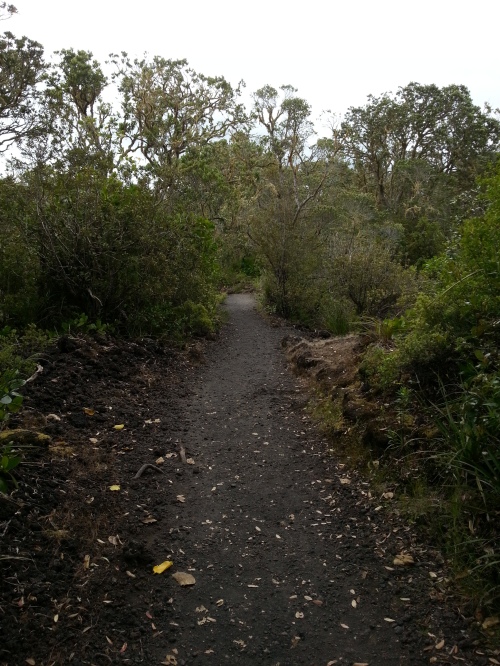
From here, Hawkins Hill is about 2.5km.  The track is a sealed road – permission for walkers has been given, but cars are not permitted on the private land without prior authorisation.  I started to walk quickly, having organised for the taxi to pick me up about 80 minutes later.

The walk was surprisingly arduous.  One factor in this was the fact I was basically wearing a suit, minus a jacket and in proper walking shoes.  The other was the wind.  It was constant and every so often overpowering, particularly when you crossed a col that was otherwise exposed.

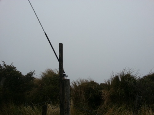
Visibility in the clouds was down to about 50m, and there are a number of false summits along the way before you reach Hawkins Hill.  For starters, make sure you keep walking past the VHF transmitter station for the airport (marked Hawkins Hill VHF station).  This is not the true summit.

Visibility behind my glasses had dropped to about 10m, and I took to doing the librarian stare to see where I was going, and having to stop more than I’d have like to keep track of how far I had gone.  For a sealed road summit, it was really quite difficult to see anything.

By the time I reached the activation zone, I was fairly exhausted: uphill, into the wind, carrying my laptop backpack and a radio, as well as being soaked to the bone and lacking in food and energy.  I found a spot where the wind was slightly stifled, set up the vertical, and started to call CQ on 17m.

I had about 10 minutes before I would need to pack up and head back down the mountain to meet the taxi.  In the end, I spotted myself on 18.140, and kept calling.  It took right up to the 9 minute mark for Ron VK3AFW to come back to the CQ, a low 4/1 signal to my 5/3.  Ron took the points for the first ZL SOTA contact, and I took the honour of the first ZL activation.

20151201_164253.jpg

The shack

Despite only one contact, I had to pack up.  No points, but association number 13 activated.  Sorry to those who were searching for me.  I will try to be QRV in Auckland over the next few days, work depending.
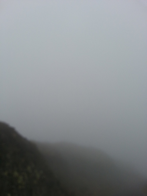
20151201_164301.jpg

The view

The walk back was quicker, but just as cold, and saved by a car descending behind me responding to my suddenly outstretched thumb.  He took me down to the gate, to where the taxi was waiting, and I headed back to the hotel then out to the airport.

Thanks to Simon the taxi driver who managed to work out ways of beating the Wellington traffic, and to the architect who drove me down the rest of the way.

So, an army marches on its stomach, so make sure you have food in you before tackling this, but it’s Wellington, so no matter what you do, you’ll always be marching into the wind.  And it’s SOTA, which means uphill!


ZL1 joins SOTA

A couple of months back, I offered to help Warren ZL2AJ with some of the heavy lifting on the surveying side for ZL SOTA.  Combining the data from LINZ with a few algorithms and a webapp I developed for the JA SOTA effort, we were able to quickly get the roughly 5,000 summits in ZL surveyed and submitted.  The first association we submitted was ZL1, North Island, and this went live on December 1.

It is worth pointing out that Warren is a surveying machine.  I managed to get about 500 of the ZL1 summits done and surveyed in the first week or so; Warren did that and about another 100, and then started working on ZL3 (South Island) almost instantly.  His work on surveying is always of a high standard too – so we had few queries from the summit teams.

Anyway, you’re all eager to travel to New Zealand, what should you do SOTA wise?

Auckland

In Auckland, there are a few summits close to the city, but none really close to the airport (hey, that’s why you put an airport a way from the city – to get it onto some flat land).  The two main ones will be Mt Eden ZL1/AK-023, a short taxi ride from the CBD, and Rangitoto Island ZL1/AK-016, a ferry ride and approximately 1 hour walk.  This also qualifies for VOTA, being New Zealand’s youngest volcano.

If you have a few more days on your hands, there are a smorgasboard of summits on Great Barrier Island, as well as three others just off shore of GBI.  GBI is a light aircraft trip from Auckland’s general aviation airport, but a few days on the Island, and a willingness to put in a few long days could see 6 or 7 summits knocked off easily enough.

Wellington

If you aren’t flying into Auckland, you’re flying into Wellington, so there are three options for you near Wellington.  The first is Hawkins Hill ZL1/WL-101, a 2.5km walk from the Brooklyn Wind Turbine along a service road.  Other options, requiring a bit more walking are Makara Hill ZL1/WL-129 and Kaukau ZL1/WL-116, both accessible from the Skyline Track.

Taranaki

Taranaki region has few summits, but Mt Taranaki (ZL1/TN-001) is a VOTA spectacular.

Bay of Plenty

Mokoia Island (ZL1/BP-217) is an island in the middle of a lake, controlled by the local Maoris.  Daily tours are available, but not sure if SOTA is an authorised activity.  Still, a fascinating little summit, standing 150m proud of the lake.

But what about South Island??

Now that North Island is live, South Island needs to be checked by the summits team.  South Island is about 3.5 times the size of North Island, so I wouldn’t expect anything before March at the earliest, if not much later.