Let me start by warning you there are going to be a number of penis jokes in this blog post. If you are at all offended by such things, I respectfully ask that you look away now. A number of photos here may qualify as NSFW – Not Safe For Work – so please also refrain if you are reading this at a work computer. In fact, get back to work.
I regularly travel to Japan for work, but have never taken my radio. Partly this is because I rarely get time outside of work, but also due to the Japanese government’s somewhat difficult approach to visiting amateurs. This time, however, I would have a full three day weekend to myself, and so I took the plunge, followed the JARL’s instructions to get a reciprocal license, and duly received the callsign JI1GBE.
Japan has no SOTA association, but more on that in another post, and so I decided to tackle some WWFF parks – JAFF-049 and JAFF-005, both readily accessible from Tokyo – 60-90 minutes on a train. With a work colleague, we decided to walk the 18km track from 陣馬高原下 (Jimbakogenshita) to 高尾山 (Takaosan). Not all of this path is within the Meiji Memorial Forest Takao Quasi-NP – JAFF-049, but we figured if we tackled it from the west, there’d be less people to encounter, and we could set up away from the busy Takaosan summit. Jimbakogenshita means ‘the place below the Jimba plateau’, and we were to climb from Jimbakogenshita to Jimbasan (a mountain) and from there to Takaosan. Neither of these mountains have the required prominence for SOTA, btw.
Now, the Japanese language has a particular grammatical form called 〜すぎます (sugimasu). You take a verb, eg, tabe (to eat), and add the sugimasu, to make tabesugimasu, which implies you’ve eaten to excess. There is a connotation of the result being bad for you in someway. Well, the night prior to our jaunt up to Takaosan I decided to take the verb 飲む (to drink) and inadvertently add the sugimasu. When I awoke the next morning at the required time (4:30am) to make the train to make the bus to Jimbakogenshita, I was still somewhat inebriated, and the lack of any open breakfast facilities at 5am didn’t help matters.
I arrived at Takao station in time to make the first bus to Jimbakogenshita (0655), and grabbed a packet of chocolate covered biscuits. I scoffed them, the breakfast of champions, while talking to my friend and work colleague Takumi, who was joining me on this escapade.
At Jimbakogenshita, we got our packs in order. I was carrying the FT-857 and the Frankenpole, plus dipoles for 10m and 12/15/20/40. I also carried 2L of water, given the humidity prevalent in Japan this time of year.
The path started out fine, walking along the road, before we deviated off into the forest. At this point the path started to climb steeply. Switchbacks are a novelty in Japan. There are a few, but by and large, it was onwards and upwards via the most direct route. About 5 minutes in, I started sweating beer. About 30 minutes in, I felt ready to die.
The humidity was repressive, although we were out of the sunshine, and these lovely old Japanese ladies kept walking past us as we stopped for a break. As motivating as that is to overtake them again – and we did – it still rankled slightly. However, I’ve long lived by the mantra, “Never run when you can walk, never walk when you can sit, never sit when you can lie down” and I used all of them to great effect in making it up the mountain. We reached the top of the mountain (a piddly 855 metres high) and I collapsed in relief. It was at this point that I wondered if I was dreaming.
Jimbasan summit
Ride a cockhorse to Banbury Cross, to see a fine lady upon a fine horse, with rings on her fingers and bells on her toes, she will have music wherever she goes
My mother had, during a stay near Banbury in 1987, recited that poem over and over again. I found the imagery strange, yet appropriate for the setting. 陣馬 (Jimba) is Japanese for ‘war horse’, a fine horse if ever there was. Many fine ladies had passed us on our trek up. There were many cowbells making music wherever we went up there. All that was missing was….

…a cockhorse
Seriously. Maybe the sculptor meant it to look like that. Maybe it was just a cock up. Maybe he was just being a dick head.

Hung like a horse. Just sayin’
All these people were milling about the summit and none of them seemed remotely disturbed by the fact the HORSE HAD A PENIS HEAD. Can you imagine the sculptor laughing with his friends about the time he sold the government a monument for a horse weiner. I wonder if his conscience was even remotely…pricked.
OK, I’m done now. Maybe. I won’t go into the photo of the horse covered in snow.
On top of the mountain stood an Udon restaurant. No way of resupply other than by climbing the stuff in, we dined on udon for breakfast. Let me tell you, this is the best thing ever. Fresh noodles and vegetables, not the 2 minute kind. Instant energy. Every mountain in Australia should have one of these on top.

Not looking remotely seedy

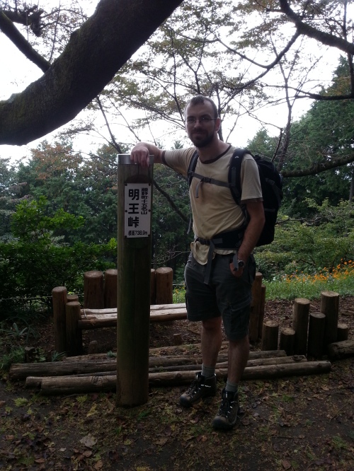
Jimbasan
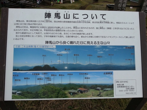
About Jimbasan
Once we finished, I decided I had the energy to do the remaining 11km to Takaosan, armed with the knowledge that it was basically downhill from Jimbasan, the highest point on the plateau. We powered down the hill on udon-power, reaching the Myouou pass/ridge (God of fire pass) in good time, well ahead of the schedule given on the trail map.

The first pass on the plateau
Trig point collecting

The path
After resting for all of two minutes, we continued on to Kagenobuyama Mountain, where we stopped for a makeshift lunch. Koganobu was where I made my first contact with another amateur, on 550nm. I dropped my bag, turned around and noticed a dipole atop a mast, with a man underneath playing radio. Tsugio Yamaguchi JH1EWV was operating on 6m right next to the trig point. I took a photo of him, of the trig point and then we had a chat and he gave me a QSL card.
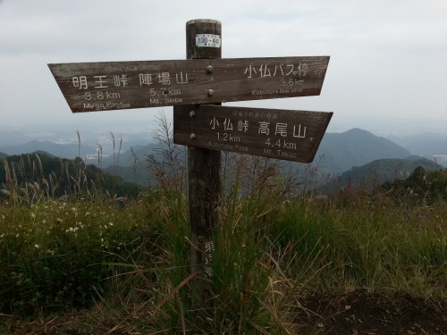
Next stop, Kobotake Pass

The Chuo expressway

Tokyo from Kagenobuyama

More trig point chasing

One ham on 6m
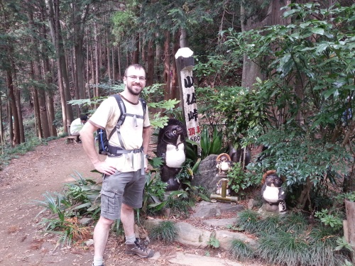
After Kagenobu, we descended down a very steep section towards Kobotake Pass. At 1.2km, I reasoned 20 minutes with Takumi. He suggested 30-35. We did it in 18. Kobotake Pass is the lowest point between Jimbasan (site of the SCHLONG HEAD HORSE) and Takaosan. At the base there was a gentleman selling topographic maps of the local area and surrounds. The quality of the maps was good, and as I have a map fetish, I bought one for the area we were walking.
Another trig point
After Kobotake, we started to climb a bit more. There were a few very steep sections, but there was also a ‘ladies route’ (not a joke about that horse) that went around the base of the climbs, which cut a fair amount of time and effort off. We took the ladies routes (three of them) and made excellent time, eventually entering the Meiji National Forest Takao Quasi-NP before reaching Shiroyama.
We bypassed Shiroyama on a ladies route, and then after a heated discussion that required the use of the new map, headed down to 1-chome, which had a southern outlook. It was here I decided to set up the radio.
I had plenty of people watching me set up the squid pole and radio on a seat off to the side of the track. There was plenty of room to stretch a 10m dipole, and I probably could have managed a 40m one if I’d not been surrounded by curious onlookers waiting to see me operate. True to form, the squid pole collapsed at one point, but we sorted that out easily enough, and I jumped on 10m, around 28.485 kHz.
My phone was almost flat by this stage, and I was struggling to get a signal out to send an SMS to alert people in VK of my presence. I sent two, but I am not sure if either made it. In any case, I received no responses to my CQ calls. I tuned around a bit and could find DX stations, and could also hear a pair of VK3s and a VK4 chatting away. This annoyingly suggested there was a path back to VK that I might have been able to use.

The operating spot
I moved to 12m, where I heard a VK4 calling CQ Africa, and then to 15m, where I was really pushing the bounds of ‘resonant’ antenna using the 10m dipole. Even so, the power meter said I was getting 40W out, of a maximum 50W per my license. I tried to break a wall of JAs in a pileup for a 9A1 station but wasn’t successful. Hearing JAs on ground wave annoyed me more as they were out there, although low down.

Operating at JAFF-049 as JI1GBE
Eventually, with Takumi along and no contacts, I decided to give up. We packed it all up, with no contacts made in JAFF-049. Next time I’ll take a slim jim to give me 2m backup.
We moved towards Takaosan, a very busy summit. On the way down, I ran into Nagasawa-san, 7N3KSO, who I spotted with a VX-3 on his backpack strap and some repeater work going on. We had a chat, although my Japanese and his English were about the same. Takumi helped to translate, and I made my second contact on 550nm. Neither valid for WWFF purposes.
After reaching Takaosan, my back was starting to hurt from carrying the load it had that day, and given I had to do work the next few days and my recent bad back history, I decided it was time to head home and rest. We took the cable car back to Takaosanguchi station, and then a semi-express to Shinjuku and Ebisu.

Tokyo from Takaosan
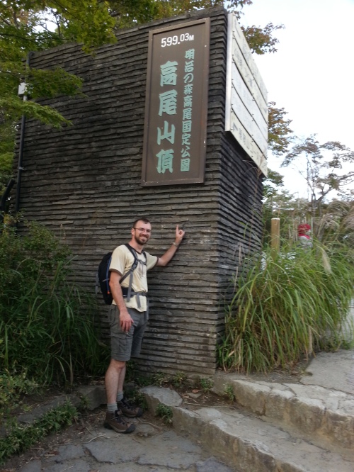
Takaosan summit
My plan to tackle 大岳山 in JAFF-005 the next day went the way of my bad back and a general case of Cantbefuctus. All up, it was a good walk, even if I felt like I was going to die at the beginning. It should also be pointed out that Takumi, my walking companion, usually runs the entire 18.5km route with another friend of his, despite the steepness. He is…an idiot. Oh, and did I mention the COCK HORSE?


